
(TheNewswire)
 | |||||||||
 |  |  | |||||||
Red Canyon Upgrades Kendal Porphyry Copper Project Potential
Vancouver, British Columbia, – TheNewswire - April 16, 2024: Red Canyon Resources Ltd. (CSE: REDC) (the “Company" or "Red Canyon") is pleased to provide a summary of its 2023 detailed exploration work on its 100% owned Kendal copper project in west-central British Columbia. The Company is focused on impactful, value-adding exploration to make discoveries of copper and copper-gold deposits in established mineral belts in North America.
Company Highlights:
-
The Company has completed a detailed lithogeochemical vectoring study and magnetic inversion modeling on its 100%-owned Kendal copper project in British Columbia. These studies have significantly enhanced our confidence that Kendal may represent a newly discovered, never drill-tested, porphyry copper system;
-
In late 2023, the Company collected over 200 rock outcrop samples throughout the Kendal area and using four-acid digestion with high-precision trace-element geochemical analyses, the Company identified important chemical enrichment and depletion zones typical of established porphyry models. Equally important, these studies suggest the erosional level of the porphyry system at Kendal could be directly above and in close proximity to the modeled zone of copper mineralization;
-
The field program also included a project-wide, 213-line-kilometre airborne magnetic and radiometric survey. Fathom Geophysics conducted modeling of the magnetic data including a magnetic vector inversion that outlines an interpreted, 2-km-long elliptical zone of magnetite destruction coincident with the core target area at Kendal;
-
Based on the results of these studies, the Company has completed final drill hole targeting in advance of an anticipated initial drill program as early as fall 2024; and
-
The Company controls a portfolio of seven 100%-owned, internally generated copper and copper–gold projects, four of which are drill ready, including Kendal.
Wendell Zerb, the Chairman and CEO of the Company, states: "Red Canyon has now completed its advanced pre-drilling exploration targeting at Kendal. We believe that the Kendal project potentially hosts a large, never drill-tested copper porphyry system. Furthermore, our detailed studies suggest that the current erosional level at Kendal is above the top of the modeled porphyry copper zone. We look forward to next steps, including diamond drilling to test this priority target. Finally, the project area is also road accessible, just a short drive from the city of Terrace, British Columbia, which is 120 km due east of developed port facilities at Prince Rupert, a significant advantage should a copper porphyry system at Kendal be defined”.
Dr. Craig Hart, Chief Geoscientist of the Company, adds: "The lithogeochemical data at Kendal is impressive. The coincident depletions and enrichments of key major and trace elements all define a region of significant high-temperature fluid flow, which when compared to our understanding of copper porphyry systems, suggests that we are above and in close proximity to the most prospective potassic alteration zone”.
About the Kendal Project
Kendal comprises five 100%-owned mineral claims totaling 2,738 hectares located in west-central British Columbia approximately 25 km northeast of the city of Terrace, a regional infrastructure hub with a well-serviced airport. Infrastructure is excellent with four intersecting highways, hydroelectric power and rail corridors and port facilities approximately 120 km to the west at Prince Rupert. The project has direct road access, only 3.5 km from Highway 16.
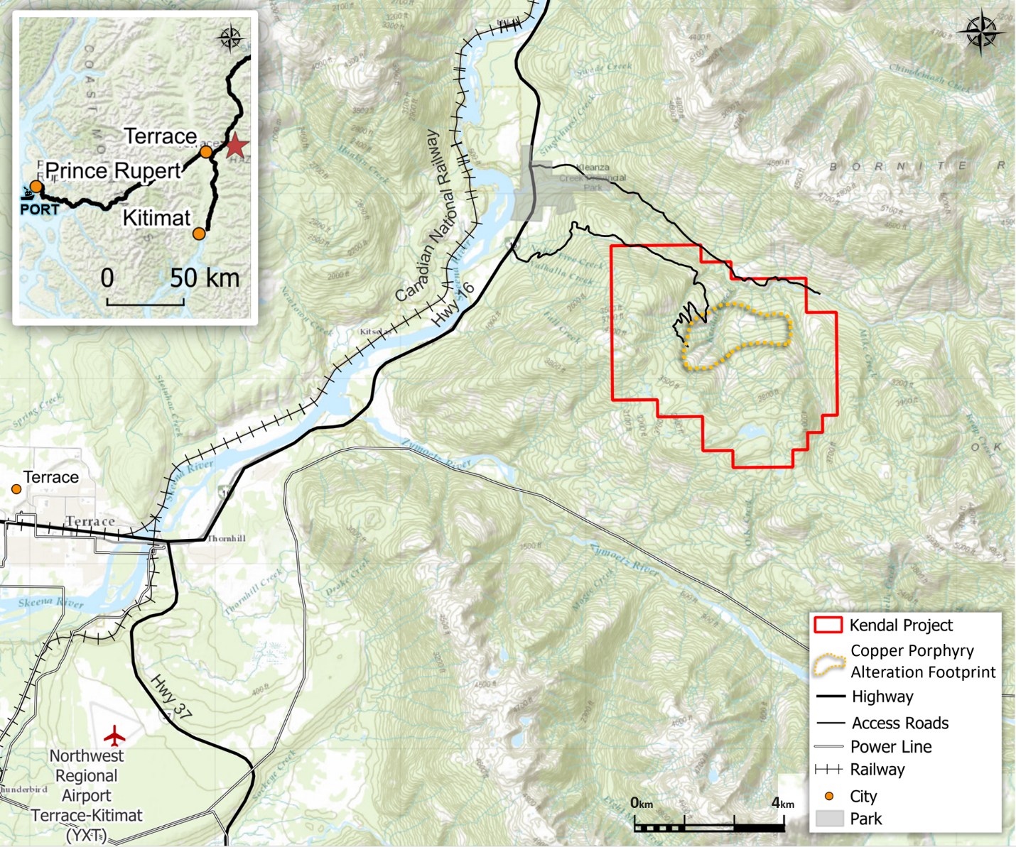
Click Image To View Full Size
Figure 1: Kendal Project location map.
A key focus of the Kendal project is the large 2.5 x 1.5 km zone of hydrothermal alteration, manifested as a phyllic zone associated with an interpreted mineralized porphyry intrusion. The Company has completed detailed geological interpretation, a lithogeochemistry vectoring study, magnetic inversion modeling and radiometric studies. These technical studies have significantly enhanced our confidence that Kendal may represent a newly discovered, never drilled, copper porphyry system.
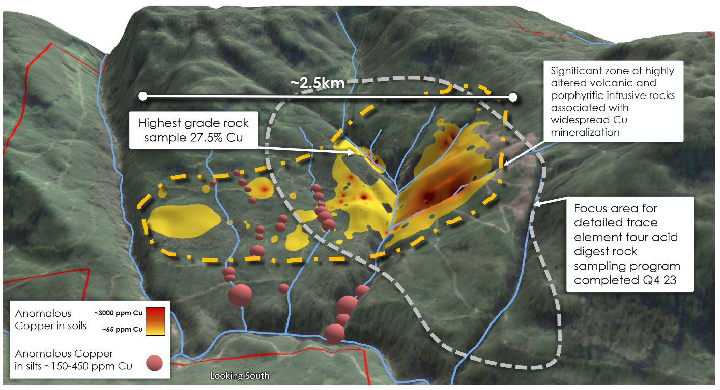
Click Image To View Full Size
Figure 2: Kendal project topographic orthophoto looking south, with outline of mapped phyllic alteration (yellow line) and focus area of the Q4/23 trace element rock sampling program (blue line).
Kendal Lithogeochemical Vectoring Study
In the fourth quarter of 2023, the Company initiated a lithogeochemical vectoring study to better understand the porphyry copper potential within the project area and approximately 200 specimens of variably altered and randomly mineralized whole rocks were collected within the area of interest (Figures 2 and 4).
The sample suite was analysed for trace element lithogeochemistry using four-acid digestion, which ensures that key minerals are dissolved. High-quality mass spectrometry is utilized to ensure high precision at low detection limits. This analytical technique allows for the recognition of subtle trends in the data that indicate hotter and potentially more proximal fluid sources, or more simply, the identification of the core of a potential mineralizing system.
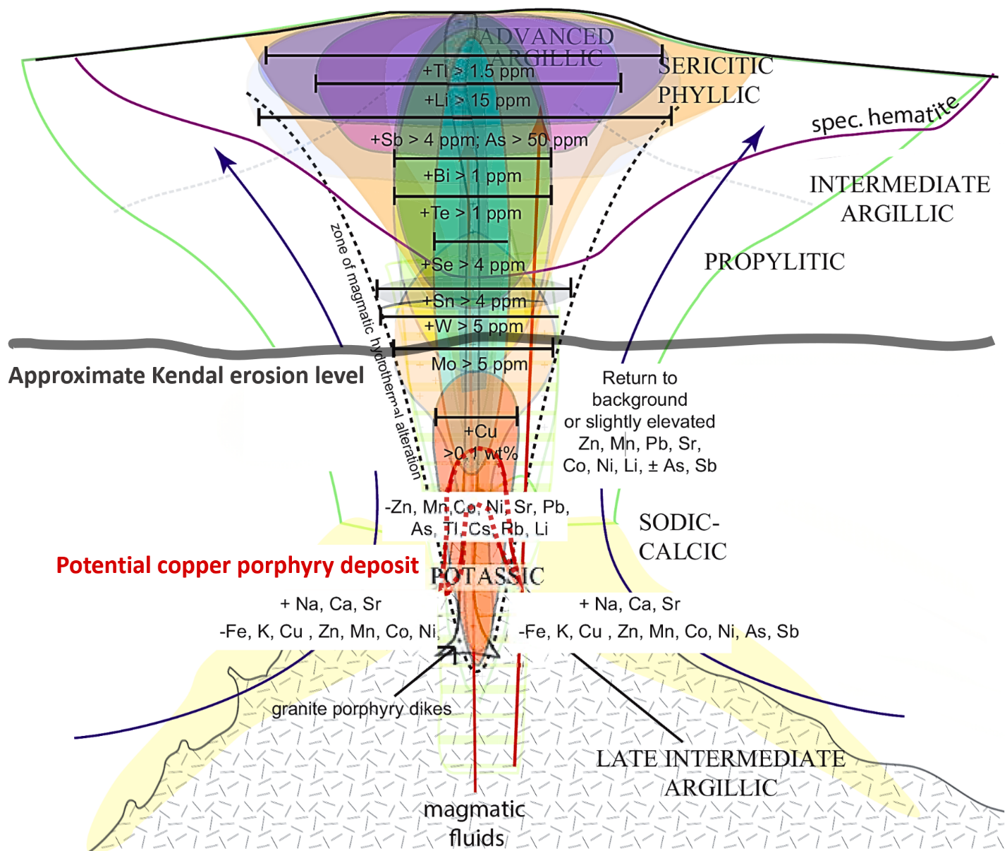
The enrichment or depletion of certain key elements provides a model of trace element behavior that reflects hotter and cooler temperatures within the vertical geochemical plume that develops above porphyry copper deposits. This enrichment or depletion forms the basis of the porphyry copper lithogeochemical footprint model of Halley et al. (2015). Interpretation of Kendal data suggests that the current level of erosion is potentially in close proximity to the most prospective potassic alteration zone (Figure 3), suggesting that the top of a copper porphyry system could be near surface.
Click Image To View Full Size
Figure 3: Geochemical data from Kendal indicates the approximate erosional level to be at the top of the magmatic-dominant portion (potassic zone) that hosts porphyry copper deposits, when compared to the Halley et al. (2015) cross-section through the porphyry copper lithogeochemical footprint model. The erosional level of Kendal is well-constrained by threshold enrichments of Mo, W and Sn, as well as Cu and depletions of Na, Mn, Sr, As, which are all characteristic of the high temperature parts of the system.
Click Image To View Full Size
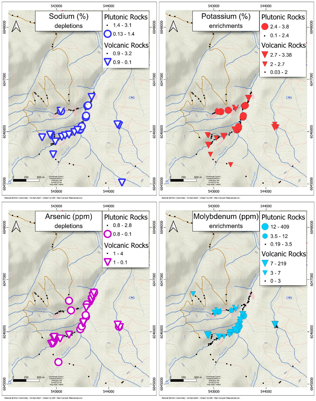
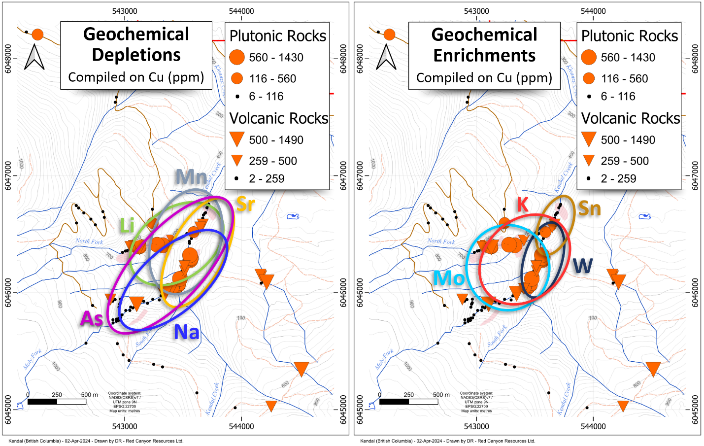
Figure 4: Examples of Kendal project lithogeochemical depletions (left) and enrichments (right) showing 3.8 x 1.6 km sample distribution that indicate significant depletions in Na and As and enrichments in K and Mo typical of high temperature alteration zones. The underlying geology is dominated by mafic volcanic rocks and related volcaniclastic sediments that are intruded by several small plutonic stocks and porphyry dykes (pale pink polygons).
The data collected by Red Canyon clearly suggests the location and distribution of the porphyry copper target on the Kendal property by a well-defined zone of Cu enrichment (>500 ppm) with numerous, coincident overlapping zones of geochemical depletion and enrichment (Figure 5). The data suggests that the threshold values of several higher-temperature copper-associated elements (Mo, W, Sn) are within the ranges expected for rocks that are often found at the top of the potassic alteration zone and immediately above a potential porphyry copper zone. This suggests a very favourable erosional level at Kendal (Figures 3 and 5). Whereas many porphyry exploration projects in altered rocks might have to drill very deep holes to potentially locate copper mineralization, the Kendal lithogeochemical footprint suggests that potential copper mineralization could be within short drill distance beneath the sampled localities.
Click Image To View Full Size
Figure 5: Maps showing compiled geochemical distributions of depleted (left) and enriched (right) elements summarized by ellipses on top of the map showing copper enrichments. The 800 x 500 metre region of Cu enrichment is overlain by coincident depletions in Na, As, Sr, Li and Mn and enrichments of K, Mo, W and Sn. Importantly, there is a >700 m sampling gap to the east of the ellipses.
Click Image To View Full Size
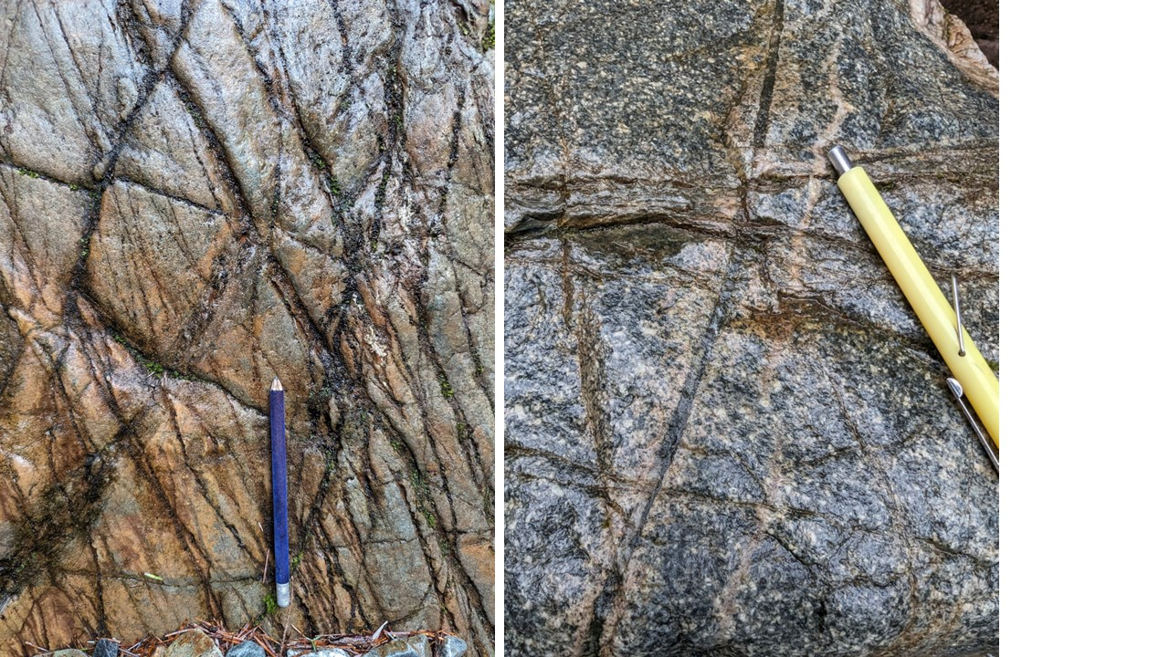
Figure 6: (left) Kendal Creek, highly-fractured and veined outcrop of intrusive rocks with an early, closely-spaced generation of parallel fractures and veins, cut by later, larger generation of sulphide-rich veins with pink weathering, possibly potassium feldspar alteration. (right) Kendal Creek outcrop with multiple generations of veins with pink alteration halos hosted in a coarse-grained and porphyritic texture intrusion. For location see Figure 2.
For a comprehensive review of the Porphyry Copper Lithogeochemical Program at Kendal and associated background model, please visit www.redcanyonresources.com.
Kendal Magnetics and Radiometrics
The 2023 field program also included a project wide 213-line-kilometre airborne magnetic and radiometric survey. Fathom Geophysics assisted the Company with modelling the magnetic data including the completion of 3D inversions.
Click Image To View Full Size
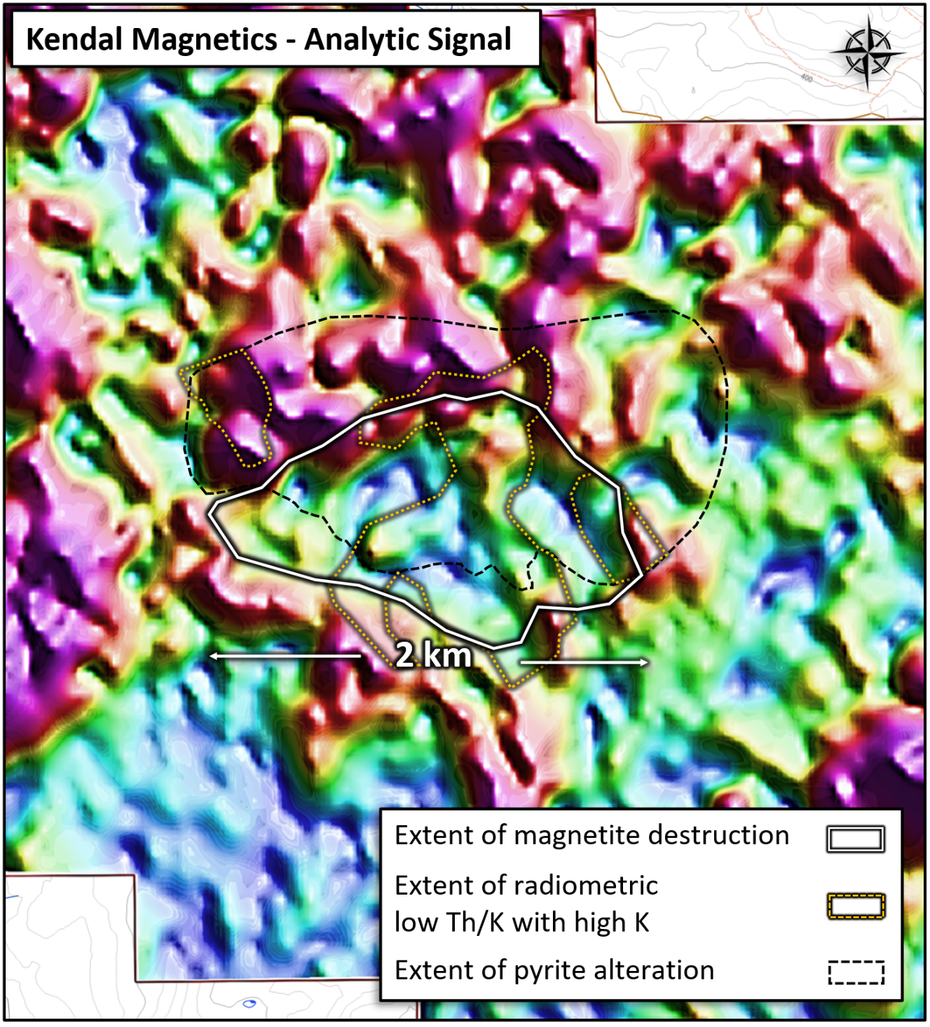
Figure 7: Magnetic analytic signal image over the central part of the Kendal project indicates a (> 2 km2) hydrothermal alteration footprint defined by a large zone of depressed magnetic response from potential hydrothermal magnetite destruction within a broader region of gossanous pyrite alteration.
Key geological, geochemical and geophysical features that are typically characteristic of mineralizing porphyry copper systems all overlap and are centered around a 600 x 600 metre region of numerous small, altered intrusions and dykes. This core area is surrounded by a nearly 2-km-wide zone of depressed magnetic responses, as seen in aeromagnetic data, outcrop and hand sample magnetic susceptibility measurements. This magnetic destruction zone (Figure 7) potentially formed from hot hydrothermal fluids that destroyed the magnetite that was originally part of the mainly mafic volcanic host rocks.
The gamma-ray radiometric response outlines areas with very low thorium/potassium (Th/K) ratios that reflect intense hydrothermal alteration through the significant addition of potassium (Figure 7), in this case mostly from sericite-alteration of mafic volcanic rocks.
References
Halley, S; Dilles, JH; and Tosdal, RM; 2015. Footprints: Hydrothermal Alteration and Geochemical Dispersion Around Porphyry Copper Deposits. SEG Newsletter 100, 1,12-18. https://doi.org/10.5382/SEGnews.2015-100.fea
Corporate Strategy
Red Canyon is focused on exploring for copper and copper-gold related mineral systems within mining friendly jurisdictions in North America, with a particular focus on British Columbia and the Western United States. The Company is specifically targeting new or underexplored areas within established, premier copper districts.
The Red Canyon team has sourced and advanced its portfolio of 100% owned projects over the last 3.5 years using leading-edge geoscience to generate new exploration ideas.
Red Canyon intends to drill test several priority projects in 2024 with a goal of bringing targets to a decision point as quickly and cost-effectively as possible. The Company intends to advance several additional projects to a drill stage by executing geologic, geochemical and geophysical programs. Red Canyon is executing a corporate strategy of seeking out strategic alliances and will evaluate opportunities to joint venture, option or sell projects to qualified partners to maximize its exposure to exploration success.
The Company’s 100% owned copper-gold Peak Project in central British Columbia is set to be drill tested in Q2/24, potentially followed by programs at Scraper Springs, Nevada and Kendal, British Columbia. Each of these projects has been advanced to the drilling stage by completing systematic, detailed geological, geophysical and geochemical programs.
Additional information on the Peak and Scraper Springs projects can be found in the NI 43-101 Technical Reports dated May 1, 2023 and September 26, 2023 respectively, as filed on SEDAR+ at www.sedarplus.ca.
Additional information on the Company’s other projects can be found on the Company’s website www.redcanyonresources.com. Further projects are in development and details will be announced as information becomes available.
About Red Canyon Resources
Red Canyon Resources Ltd. (CSE: REDC) is a geoscience-driven, discovery-focused mineral exploration company focused on exploring North America’s top copper jurisdictions. The Company’s core goal is to make impactful copper discoveries to benefit all stakeholders and aid in the clean energy transition. Red Canyon has a portfolio of 100% owned copper and copper-gold porphyry exploration projects. The Company’s technical team consists of experienced geoscientists with diverse capital market, small cap and major mining company backgrounds, and a track record of success.
For more information, please visit the Company's website at www.redcanyonresources.com.
Red Canyon is part of the NewQuest Capital Group which is a discovery-driven investment group that builds value through the incubation and financing of mineral projects and companies. Further information about NewQuest can be found on the company website at www.nqcapitalgroup.com.
On Behalf of the Board of Directors
Wendell Zerb, P. Geol
Chairman and Chief Executive Officer
+1 (604) 681-9100
For further information, please contact:
Brennan Zerb
Investor Relations Manager
+1 (778) 867-5016
Lithogeochemical Sampling and Analytical Procedure – The Lithogeochemical samples were collected by rock hammer over a predetermined sampling area, based on outcrop exposure in the Kendal area. Sample locations were generated by Garmin hand-held GPS units. All samples were geologically characterized and photographed at the Company’s field office. Samples were prepped and cut to remove any notable oxidation. Rock samples were placed in numbered bags for analysis, with a sawn rock half-sample stored as a representative sample. Samples were dispatched to ALS Laboratories an accredited analytical laboratory meeting ISO/IEC 17025:2005 and ISO 9001:2015 standards. Samples are prepared by crushing and grinding via ALS methods CRU-21 and PUL-32 respectively. A 25 g aliquot of each pulp is subjected to a four-acid digestion and analyzed for 48 elements by ICP-MS finish (ALS code ME-MS61). QAQC including laboratory standards, are monitored by the Company. All lab data was compiled and statistically categorized by Red Canyon geoscientists.
Qualified Person - The technical information contained in this update has been reviewed and approved by Wendell Zerb, P. Geol, a “Qualified Person” (“QP”) as defined in National Instrument 43-101 – Standards of Disclosure for Mineral Projects.
Forward-Looking Statements:
This news release includes certain forward-looking statements and forward-looking information (collectively, “forward-looking statements”) within the meaning of applicable Canadian securities legislation. All statements, other than statements of historical fact, included herein including, without limitation, statements regarding future capital expenditures, exploration activities and the specifications, targets, results, analyses, interpretations, benefits, costs and timing of them, and the anticipated business plans and timing of future activities of the Company, are forward-looking statements. Although the Company believes that such statements are reasonable, it can give no assurance that such expectations will prove to be correct. Often, but not always, forward looking information can be identified by words such as “pro forma”, “plans”, “expects”, “may”, “should”, “budget”, “scheduled”, “estimates”, “forecasts”, “intends”, “anticipates”, “believes”, “potential” or variations of such words including negative variations thereof, and phrases that refer to certain actions, events or results that may, could, would, might or will occur or be taken or achieved. Forward-looking statements involve known and unknown risks, uncertainties and other factors which may cause the actual results, performance or achievements of the Company to differ materially from any future results, performance or achievements expressed or implied by the forward-looking statements. Such risks and other factors include, among others, risks related to the anticipated business plans and timing of future activities of the Company, including the Company’s exploration plans and the proposed expenditures for exploration work thereon, the ability of the Company to obtain sufficient financing to fund its business activities and plans, the ability of the Company to obtain the required permits, changes in laws, regulations and policies affecting mining operations, the Company’s limited operating history, currency fluctuations, title disputes or claims, environmental issues and liabilities, as well as those factors discussed under the heading “Risk Factors” in the Company’s prospectus dated October 12, 2023 and other filings of the Company with the Canadian Securities Authorities, copies of which can be found under the Company’s profile on the SEDAR website at www.sedar.com.
Readers are cautioned not to place undue reliance on forward-looking statements. The Company undertakes no obligation to update any of the forward-looking statements, except as otherwise required by law.
Copyright (c) 2024 TheNewswire - All rights reserved.